HotelsLine Blog Town - Region
image

Platanos in Mountainous Nafpaktia

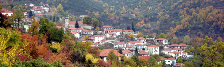
Platanos used to be the capital of the original rather small municipality of Proschios (with Klipaida and Pyllini) and then the capital Platanos municipality. Kato Platanos (former Vonorta) also belongs to this district. It is located on the eastern slopes of mount Alonaki (altitude 1418 meters) at an altitude of 860 meters.

It is located within a beautiful forest with diverse flora (fir, cedar, cornel trees and others). It seems that before Platanos was built in its present location there were small settlements in the areas Bourlada, with the church of the Tehotokos (Paliokklisi) Pogoniska with the church Agia Paraskevi, Palialonia, Pognia, Aye Vlasis and Valsamos. There is also a scenario that in addition to these settlements there was a settlement in “Megali Vrysi” area which attracted the other settlements due to its healthy climate. It cannot be ruled out though that from Platanos settlement, which got its name from the plane tree of “Megali Vrysi”, the above small settlements were created for farmland purposes. Traces of ancient ruins have been found at Pougouiska, Pourlada Vonorta (St.Taxiarches), St. Athanasios (Milia), Fteri (St. George) and Megali Vrysi. Some of the findings have been timed at the post classical times by archaeologists.

Platanos has a long history; it was a prosperous and rich village. The number of stores that existed verifies this fact. Platanos is a traditional settlement.

Stone houses are a majority and arouse great interest. Rontiraika (1847), the house of Margarits (1850), the house of Kolotourou (Koletta 1840) and the house of Aggelaki (1850) all with impressive rock reliefs are some of the oldest houses of Platanos. The St. Nikolas church stands out (1846) grandeur and domineering at the centre of the village. Its rythm is basillic with two beauteous and castellated steeples and a triconch arch on the altar, rare structural art. Impressive are the stone reliefs of the doorframes of the southern part of the church. Majestic is also the interior of the church with icons and heirlooms of great value.

Noteworthy at the square of the village are two museums: a) National Resistance museum with photographic archives and a collection of related books and documents, b) the history – folklore museum with a significant collection of historic and folklore elements. As you walk through the cobblestone streets you may see other important buildings of the settlement like the school and the health centre, the rock faucets and the bust statues of Karaiskaki who had militarilize Platanos as well as eminent personalities of Platanos.
Megali Vrysi, a climb to the forest, a visit to the churches (Holy Archangels, St. George, St. Elias, St. Paraskevi) and to other picturesque spots of the village are some of the greater or smaller routes a visitor can take. South of Platanos is Kato Platanos (former Vonorta) settlement. It is a byzantine village and during that times (1454) it was a bit larger (population-wise) than Platanos.

Source: Municipality of Nafpaktia


Accommodation
For your stay in Mountainous Nafpaktia, Agrinio town, Messolonghi and the rest areas of the prefecture, you can book a room in one of the hotels and Bed & Breakfast inns.
In AgrinioMessolonghi as well as in many other areas of Aetoloakarnania County, there are hotels and accommodations of various categories and types (rooms to let, residences, Bed & Breakfast inns, studios, hostels, guesthouses and furnished apartments) that can satisfy every visitor's demands and needs for a pleasant and enjoyable stay.
You will find wonderful hotels, rooms and apartments to let of all categories and price ranges.


Access
By car:
You can access Aetoloakarnania by car using the road network.
The best way to explore and wander around in Aetoloakarnania, known for its many natural beauties and major attractions, is to have your own transport. It is worth visiting places that the local transport and tours do not reach.

Indicative distances and routes from Messolonghi:
Agrinio: 37 km Route Map. The road route from Messolonghi to Agrinio. The distance in kilometers and time that you will need to get there
Athens: 244 km Route Map. The road route from Messolonghi to Athens. The distance in kilometers and time that you will need to get there
Thessaloniki: 424 km Route Map. The road route from Messolonghi to Thessaloniki. The distance in kilometers and time that you will need to get there
Patra: 49 km Route Map. The road route from Messolonghi to Patra. The distance in kilometers and time that you will need to get there
Ioannina: 181 km Route Map. The road route from Messolonghi to Ioannina. The distance in kilometers and time that you will need to get there
Preveza: 123 km Route Map. The road route from Messolonghi to Preveza. The distance in kilometers and time that you will need to get there

By bus:
Regular Aetoloakarnania Intercity bus Access Map. How to get to Aetoloakarnania Bus in Agrinio routes connect the main and major cities of the prefecture to Athens and capitals of other prefectures.
There is also regular connection of areas, villages and regions of the county.

The region of Agrinio has a good road network which makes transportation easy through all villages and settlements.
In the city of Agrinio you may also use the urban bus. tel (+30) 26410.57.851.

Related articles:
For your convenience, you can use the route map on the field “Routes” with information about the mileage, the time you need and the route you will follow, selecting the points of interest.


Articles

Accommodation in Mountainous Nafpaktia

For your stay in Mountainous Nafpaktia, you can book a room in one of the hotels and Bed & Breakfast inns. In Ano Chora...

Location articles: Mountainous Nafpaktia

Articles, tributes and reviews for the location with useful information and suggestions...

Routes
Search location


From business to location


� Hotelsline 2025 All right reserved. Wildcard SSL